Snow water equivalent in GlobSnow-2 datasets
Snow water equivalent (SWE) can be determined using microwave sensors. There are several different passive microwave sensors onboard different satellites: SSM/I, SSMI/S, AMSU, and AMSR-E. SWE products for Europe are available from Hydrological SAF (H-SAF) and GlobSnow projects. Both consortiums use the same instruments and very similar algorithms to produce SWE products. H-SAF's SWE product is generated every day with a delay of 12 hours, and can be applied operationally. Data used by the GlobSnow project covers a much longer period (from 1979 to 2013) and thus can be used for climate research.
GlobSnow is a project funded by ESA (European Space Agency) which provides snow cover products for the northern hemisphere. The GlobSnow-2 snow water equivalent (SWE) product (25×25 km) is derived using a combination of ground-based data and satellite microwave radiometer-based measurements over the northern hemisphere (Fig. 1). The passive microwave data includes radiometer information of the SMMR (Scanning Multichannel Microwave Radiometer) for 1979-1987 and SSM/I (Special Sensor Microwave/Imager) for 1987 to present.
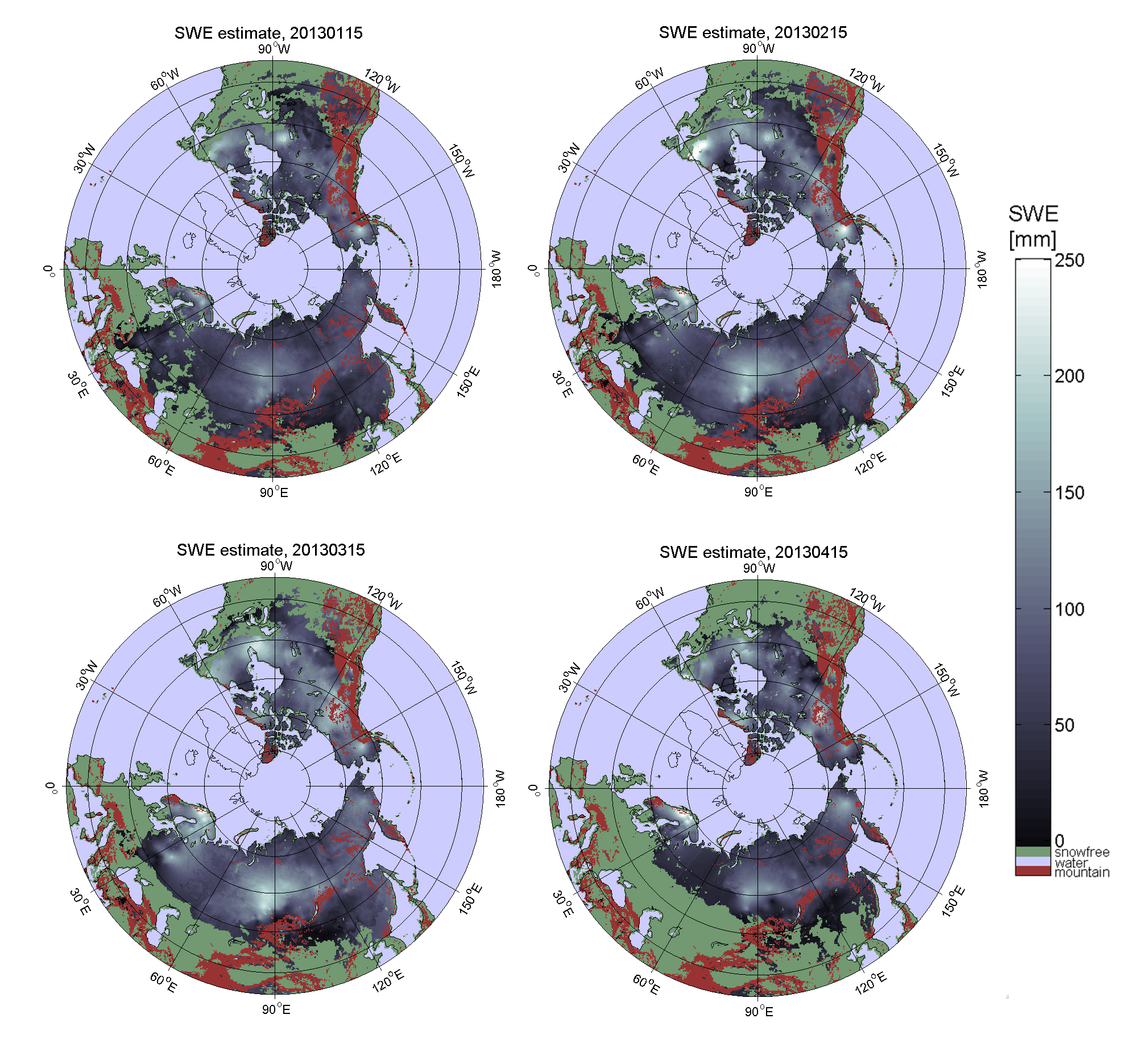
Figure 1: GlobSnow-2 northern hemisphere SWE product for January-April 2013. The images (from left to right) show how the snow line moves north as the melting season proceeds.
GlobSnow-2 SWE estimation is based on an assimilation technique which weights the space-borne microwave data and snow depth (SD) interpolated from synoptic, near real-time in-situ observations with their estimated statistical accuracy (Pulliainen, 2006). Satellite-derived estimates of snow depth are based on an emission model that uses two frequencies, 18.7 and 36.5 GHz. This channel difference is the index most commonly used to derive SWE or SD (Luojus et. al, 2010). SD estimates are first calibrated over EASE grid cells with available SD measurements from ground stations. Snow grain size determined from the input radiometer is used in the model as a scalable input parameter. These values of grain size are used to construct an interpolated background map of the effective grain size. The map is then used as an input in model inversion over the span of available radiometer observations, providing an estimate of SD. In the inversion process, the effective grain size in each grid cell is weighed with its respective error estimate. A snow density value is applied to each grid to determine SWE from the SD estimation. Areas of wet snow are masked according to observed brightness temperature values using an empirical equation (Luojus et. al, 2010).
Due to the characteristics of passive microwave observations, the SWE product is more reliable for areas with dry snow cover (Fig. 2). Microwave brightness temperature increases with the snow's wetness, but decreases as snow grain size increases, independent of the change in SWE. Areas with sporadic wet snow or thin snow layers are not reliably detected and typically are not present in the SWE product. The areas marked as snow-free may thus include areas with occasional wet snow cover.
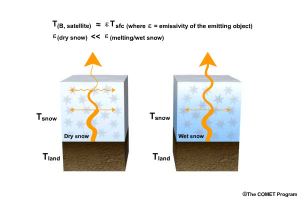
Figure 2: Emissivity of wet snow is very different compared to dry snow. Credit: COMET®.
Shallow snow cover is difficult to detect with passive microwave measurements, but they are usable when the snow's properties reach certain threshold values. Passive microwave SWE retrieval algorithms have a well-documented tendency to systematically underestimate SWE when the snow cover is deep due to a change in the microwave radiation behavior of the snowpack; when SWE exceeds approximately 150 mm, the snowpack changes from a scattering object to a radiation source (Takala et al., 2011). Satellite-derived SWE errors may also be caused by the snowpack mass, the distance to significant open water bodies, snowpack morphology changes due to melting and refreezing, forest cover, type of snow, and topographic factors such as roughness (Dong et al., 2005).
To overcome these problems, the GlobSnow consortium has introduced a new SWE dataset that is based on an assimilation scheme that uses passive microwave radiometer data and in-situ measurements of snow depth in combination with a melt detection algorithm. However, in certain months data availability is reduced to individual days because the assimilation algorithm is not able to produce good SWE outputs. In late spring and early autumn, problems with SWE retrieval occur because of difficulties in using radiometer data when a thin snow layer or wet snow is predominant (Klehmet et al., 2013). Mountainous regions in the GlobSnow products were masked out due to the poor algorithm performance in orographically complex regions (Takala et al., 2011).
Exercise 6
Chose statement which is FALSE
The FALSE statement is:
b) SWE retrieval algorithms have a well-documented tendency to underestimate (not overestimate!) SWE under the deep snow conditions.