Special features
Some meteorological systems are easier to visualize using cross sections then on pressure levels and for some systems or features cross sections give very valuable additional information. In everyday synoptic practice vertical cross-sections are used in parallel to other synoptic material therefore a synoptician can recognize many systems or processes just by looking at the cross section.
In the following chapters you can find the examples of systems or features which are remarkably visible in the cross sections and for which synoptic analisys without cross sections would hardly be possible at all. These are frontal systems (cold front, warm front and occlusion), potential vorticity anomalies, inversions, vertical wind shear and jet streak, dry intrusion and severe convection.
Some of these features can be recognized from the shape of the isentropes in the cross-sections and some features are connected to other meteorological parameters.
Configuration of the isentropes and some relevant parameters within the frontal zones
In the cross sections, isentropes are especially useful for detecting frontal zones. Fronts are presented as zones of high θ gradients, inclined downward from high levels, for instance 300 hPa, to the ground (in the case of a surface front). Cold and Warm Fronts as well as Occlusions can be differentiated in this way.
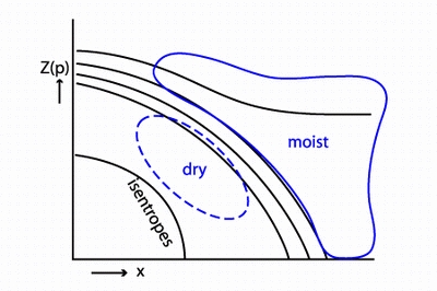 |
COLD FRONT
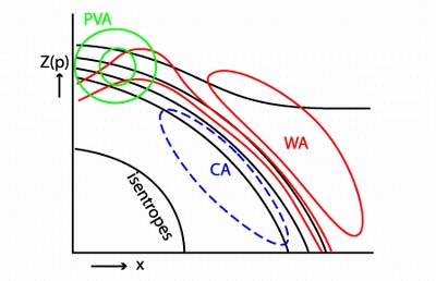
In the cross section of the cold front layed from cold to warm air the frontal zone is represented by downward (or backward) inclined zone of high gradient of the isentropes. As explained in chapter "Potential and equipotential temperature", higher θ represents warmer air while lower θ represents colder air. This means that if you look in the same pressure level (or height) you will find lower θ values (colder air) behind the front and higher values (warmer air) ahead of it. Besides the slope, the intensity of the frontal zone can be judged by the distance between the isentropes in the cross section. If the isentropes are very crowded (potential temperature gradient is high) it means that the temperature change within the frontal zone is large, therefore a front can be considered as more intensive. Humidity distribution around the frontal zone is also depicted. There is a backward inclined zone of high humidity on top of the frontal zone and dry air below the frontal zone. Cold air is advected behind the front and warm air ahead of it. That can be seen in the temperature advection cross-section. |
 |
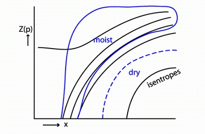 |
WARM FRONT
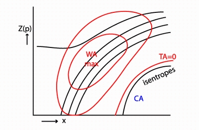
In the cross section across the warm front the isentropes are inclined forwards (or upwards). This means that at the same pressure level warmer air is found behind the frontal zone, and colder air ahead of it. Usually the slope of the isentropes in the warm front is never so steep as it can be in the cold front and the isentropes are usually less crowded - temperature change within the warm frontal zones is never so intense as within the cold fronts. There is also a forward inclined zone of high humidity that follows that slope of the isentropes and is located above the frontal zone, whereas dry air is found beneath and in front of the zone of high gradient. Warm front is also characterized by strong warm advection maximum which is usually found within the whole region of the warm front. Cold advection, on the other hand, is found below the frontal zone. |
 |
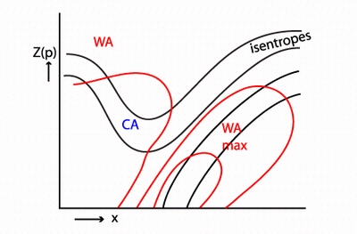 |
OCCLUSION
In the occlusion fronts the isentropes usually form a typical X or Y shape showing that cold and warm fronts are meeting. The trough that the isentropes form in the cross-section represents warm air. The schematics here show a Warm Front Occlusion, therefore the frontal zone of the warm front is seen in the lower layers. Maximum of warm advection is found in the warm front area and at the leading part of the isentropic trough, whereas cold advection occurs behind and above the isentropic trough. |
Seeing the sketches of the fronts, you might be interested what this cross-sections look like in the real atmosphere. Just follow this link and you will see the example of a real frontal system and several cross-sections accros it!